Unfortunately we are being forced to cancel the 2021 Cherohala Marathon due to slow permitting process with the Cherokee National Forest.
Full refunds have been made. It can take 24-72 business hours to appear on your statement.
We are submitting an application in the first weeks of May 2021 for 2022 and we hope to see you next year.
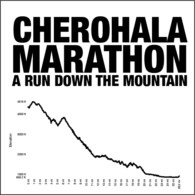
Cherohala Marathon: A Run Down the Mountain
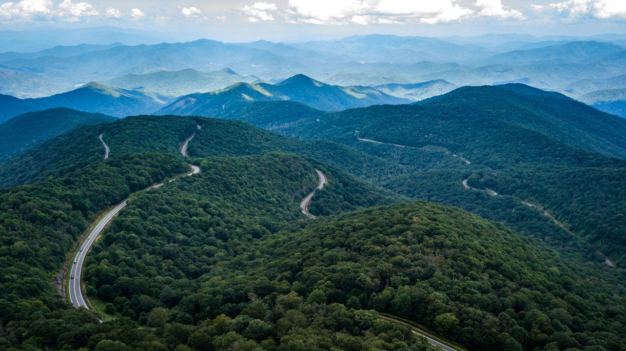
Come join us for a run down the scenic Cherohala Skyway. With over 3,500 feet of descent into Tellico Plains, TN, the Skyway offers stunning overlooks, access to hiking trails, and waterfalls along the way.
The Cherohala Skyway is a 43-mile National Scenic Byway and National Forest Scenic Byway that connects Tellico Plains, Tennessee to Robbinsville, North Carolina in the southeastern United States. Its name is a portmanteau of Cherokee and Nantahala, the two national forests through which it passes.
Permit Pending National Forest Approval. If the event permit is not granted, full refunds will be made.
Cherohala Marathon
Staged at Tellico Plains High School in Tellico Plains, TN
June 27, 2021
EVENT DETAILS
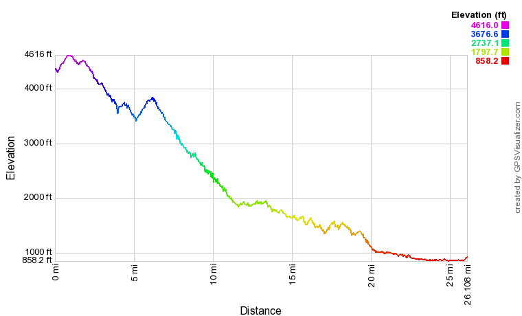
- RUN DESCRIPTION: Mostly downhill marathon with over 3,500 feet of descent (see profile above)
- LOCATION: Course starts at the intersection Old Santeetlah Road and the Cherohala Skyway. The finish (and shuttle staging) is located at Tellico Plains High School in Tellico Plains, TN
- START TIME: 7:00 AM
Shuttles will depart Tellico Plains High School at 6:10 am.
MARATHON COURSE DESCRIPTION & MAPS:
- Full Marathon is limited to 400 runners
- Total Elevation Loss=3,758 ft
- 7.5 hour cut-off time AND a 6 hour cut-off time at mile 22.
- If runners do not maintain a 16:20 min/mile pace then course marshals reserve the right to pull you from the course for your safety.
- MapMyRun Link - https://www.mapmyrun.com/routes/view/3829700503
The course begins with a small climb from the start to the Cherohala Skyway and descends to Tellico Plains. There is another significant climb at 5.2 miles and begins descending after a mile (169 feet total climbing from 5.2 to 6.2 miles).
The route will be marked with directional signage and mile markers. Aid stations will also be provided at intervals approximately every 3 miles. The aid stations will be placed off the road at safe pull offs or on a road spur.
Aid stations will be touchless and include water, Gatorade, GU, fruit, and other goodies.
Start – Water and Portojohns Provided
Aid Station 1 – Located at Fall Branch Road (3 Miles)
Aid Station 2 - Eagle Gap (6.5 miles)
Aid Station 3 – Indian Boundary Road (11.1 miles)
Aid Station 4 – Hemlock Road (13.5 miles)
Aid Station 5 - Turkey Creek Road (16.8 miles)
Aid Station 6 – Odell Road (19.5 miles)
Aid Station 7 – Quarry Creek Road (23.9 miles)
Camping will be available in the National Forest near the start and other lodging available near Tellico Plains.
Camp sites and amenities available at Rattler Ford Campground, Cheoah Ranger District, Nantahala National Forest. Primitive camping available near Stewart Cabin/
Directions: From Interstate 75 - take Exit 60, turn south on TN 68 for approximately 30 miles. In Tellico Plains, turn left on TN 165 (Cherohala Skyway).
